BALTIMORE -- The U.S. Army Corps of Engineers, Baltimore District (USACE), in coordination with the Maryland Department of Transportation Maryland Port Administration (MDOT MPA), is holding a public meeting Feb. 24 from 6 – 8 p.m. to provide information on the Seagirt Loop Channel Deepening Feasibility Study draft Integrated Feasibility Report and Environmental Assessment (EA) and to solicit input.
This meeting will provide stakeholders and the public the opportunity to learn more about the Seagirt Loop Channel Deepening Feasibility Study and resulting feasibility report and EA, which will determine whether improvements to the Baltimore Harbor Anchorages and Channels project would result in improved navigation efficiencies at the Port of Baltimore to help meet demand for future capacity at the Port facilities, including efficient handling of increased container volume at Seagirt Marine Terminal (SMT) and faster and safer movement of vessels transiting the channels.
The study examined navigation efficiencies and transportation cost savings that could be gained by improving the Seagirt Loop Channel to better accommodate the ultra large container vessels, or “Post-Panamax vessels”, calling at SMT. These vessels can carry twice the cargo capacity and require deeper water depths than the ships that were used to design the current access channels to the SMT and have a greater risk of grounding, collision, allision, and marine casualties. Along with these risks, efficiency delays have resulted in limitations to operations within Baltimore Harbor.
The study area includes 32-square miles of Baltimore Harbor, including the navigable parts of the Patapsco River below Hanover Street, the Northwest and Middle Branches, and Curtis Bay and its tributary, Curtis Creek, as well as the associated Port.
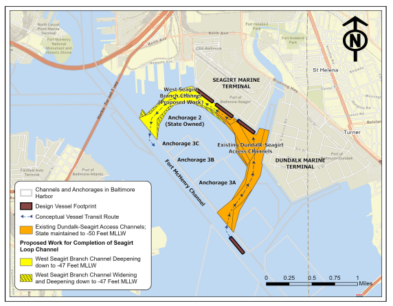
USACE and MDOT MPA will present two proposed plans detailed in the draft report; the Tentatively Selected Plan, which proposes widening and deepening of the West Seagirt Branch Channel (WSBC) to a federally authorized depth of at least 47 feet mean lower low water (MLLW), shown below in Figure 1; and the Locally Preferred Plan, which proposes widening and deepening of the WSBC to complete the Seagirt Loop Channel at an authorized depth of at least 50 feet MLLW.
The draft Integrated Feasibility Report and EA is available to the public for a 30-day review and comment period beginning on Feb. 9, 2022. Comments can be submitted electronically to CENAB-CC@usace.army.mil and need to be received on or before March 11, 2022, to be considered. Both documents and other relevant info is available on the USACE website at https://www.nab.usace.army.mil/Missions/Civil-Works/SeagirtLoop-Channel/.
A hard copy of these documents is available at the Sollers Point Branch Library, located at 323 Sollers Point Road, Dundalk, Maryland. It will be held at the front desk and made available to the public upon request.
Virtual Public Meeting Details Date/time:
Thursday, February 24, 2021, at 6 p.m.
Interested participants can register in advance for this meeting at the hyperlink below. After registering, you will receive a confirmation email containing information about joining the meeting.
Zoom Link: https://moffattnichol.zoom.us/meeting/register/tZUocuCqrTIpGNxhBtfcqQZOnJPChveSyfqy

Figure 1. TENTATIVELY SELECTED PLAN - DEEPENING AND WIDENING OF THE WEST SEAGIRT BRANCH CHANNEL