Levee Safety Risk Assessments

*Click to enlarge/download


View Levee Safety Risk Assessment Video

The Baltimore District currently has 150 miles of federally-constructed levees in the Corps Levee Safety Program that help manage flood risk in southern New York, central Pennsylvania, Maryland, northern Virginia, eastern West Virginia and Washington, D.C.

Risk is managed by routine Levee Safety Program activities, including operations and maintenance, inspections and risk assessments. This program ensures the comprehensive evaluation of our levee systems to manage potential risks to people, property, and the environment.

It is a priority for the Corps to assess how levees are expected to perform and what the potential consequences of non-performance (water coming over top of them, breaches or breaks in the levee) would be. Placing levees into risk categories provides a consistent way to prioritize actions that will help manage the risks associated with owning or operating levees. The Corps uses risk assessments to prioritize life safety risks for its own levee safety activities, and also to provide a basis for communicating risk, so levee sponsors and other stakeholders can make more informed decisions.

The use of risk assessments complements traditional approaches to levee safety, such as inspections; it does not replace them. Risk assessments provide a better understanding of the risk associated with living behind a levee through the likelihood of the levee having flood water on it (flood frequency in the area), anticipated performance of the levee during a high-water event (based on its condition) and consequences if the levee is overtopped by water or breaches (people and property behind levee). These risk assessments help the public understand the risk associated with living behind a levee, and it helps agencies who operate and maintain the levee systems make informed decisions to prioritize funding and take actions to reduce flood risk.

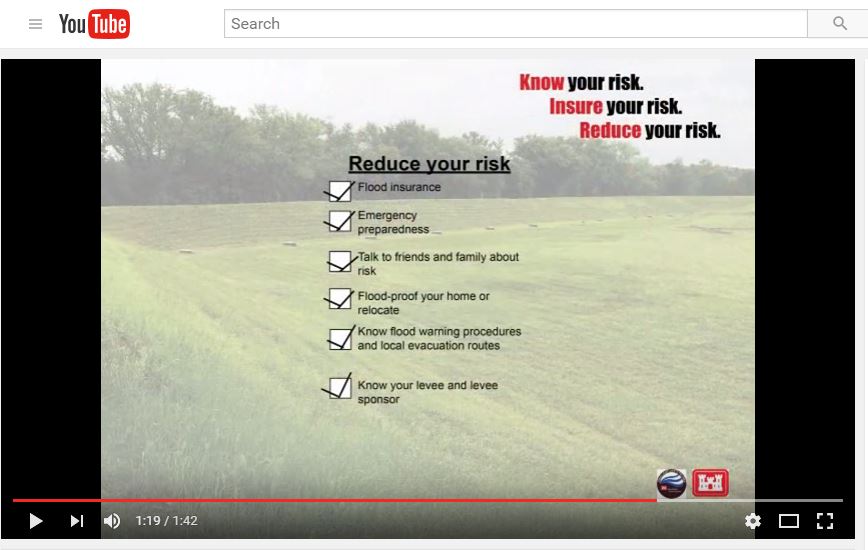
Levees help manage risk; they do not eliminate the risk. Storms can be unpredictable and risk factors are always changing. We all have a role to play in reducing our flood threats. As a member of the public, you are encouraged to know your risks, follow your local emergency preparedness plan, and appropriately insure your risks.  

Through the Levee Safety Program, the Corps will continue to look critically and rigorously at the resiliency and vulnerability of our levees, nationwide, and help drive down risk together with all of our partners.


How Levee Risk is Calculated

*Click to enlarge the graphic

An initial risk assessment uses basic information from the National Levee Database; existing engineering and hydrologic data; results of inspections conducted with our sponsors; historical data, such as observations during flood events; and other sources such as FEMA’s HAZUS database that uses GIS technology to estimate physical, economic and social impacts of disasters.

The level of risk is based on the levee condition and available data at the time of the screening. Flood frequency, levee performance assessment, and consequence estimation are three major components of a levee screening.

1.) How likely is the levee to get wet? The most recent information on the frequency and severity of flooding along the leveed area, how the water moves, and the history of breaching (a break in the levee) and overtopping (water coming over the levee) of the system is used to determine the frequency of water on the levee.

2.) How will the levee perform during the next flood (what is its condition)? The most current levee inspection, performance history, flood-fight records, photos, and design documentation are used in completing engineering-based performance assessments.

3.) If the levee breaches or overtops during a flood, what are the consequences? The consequences include an estimate of the number of people living and working behind the levee and direct economic damages (number of properties, critical infrastructure). Other elements for consequences include the level of community awareness and the presence or absence of effective warning systems and evacuation plans.  


Making Sense of the Risk Assessment Results

*Click to enlarge the graphic

Levee systems fall under one of the following risk classifications: Very high risk; High risk; Moderate risk; Low risk; and Very low risk.


Placing levees into risk categories helps prioritize limited resources to drive better flood risk management decisions at the federal and local levels.


The risk level is determined through assessing the safety risk based on the three aforementioned factors of likelihood of flooding in the area, anticipated performance (condition) of levee and consequences if the levee were to break or overtop with water. It is important to note that even if a levee is in excellent condition, it still may be classified as high risk because of the high population and resources in the leveed area.


Baltimore District is mainly comprised of moderate to low risk levee systems.


Levee FAQs

Collapse All Expand All
 

How are levee risk assessments conducted?

An initial risk assessment uses basic information from the National Levee Database; existing engineering and hydrologic data; results of levee inspections conducted with our sponsors; historical data, such as observations during flood events; and other sources such as FEMA’s HAZUS database that uses GIS technology to estimate physical, economic and social impacts of disasters, and puts it in a consistent framework for answering key questions regarding priorities, relative risk, and type of action.

The level of risk is determined based on the levee conditions and available data at the time of the screening. Flood frequency, levee performance assessment, and consequence estimation are the three major components. The most recent hydrologic and hydraulic information is used to determine the frequency of water on the levee. The most current levee inspection, performance history, flood-fight records, photos, and design documentation are used in completing engineering-based performance/condition assessments. The consequences include an estimate of the population living and working behind the levee and direct economic damages, as well as critical infrastructure like hospitals.


Where can I find information about the levee I live or work behind?

The National Levee Database web site that also includes results from previous inspections.
 

How do these risk assessments tie into routine and periodic inspections?

The use of risk assessments complements traditional approaches to levee safety, such as inspections; it does not replace them. They are just another component within the levee safety program to ensure the comprehensive evaluation of our levee systems to manage potential risk to people, property, and the environment. A risk assessment provides a better understanding of the likelihood of flooding, anticipated performance of the levee during a flood, and consequences if the levee were to break or overtop with water. It also helps establish potential solutions to reduce the flood risks. Additionally, risk assessments help determine where to prioritize flood risk management actions through grouping levee systems by their associated risk. 

We regularly inspect levees within our inventory to monitor their overall condition, identify potential deficiencies, verify that needed maintenance is taking place by the levee’s sponsor, determine eligibility for rehabilitation assistance if damaged in a storm, and provide the sponsor and public with information about their levees. Levee inspections typically occur annually with more in-depth inspections occurring every five years.


What’s the purpose of the risk assessments?

Following Hurricane Katrina, the need developed to create an inventory of all federally constructed levees and assess their conditions and safety risks. This goes beyond the regular inspections we conduct on the levees.

Placing levees into risk categories provides a consistent way to prioritize flood risk management actions and limited funding resources. These assessments help the public better understand the risk associated with living and working behind a levee, and it helps the community and local agencies make decisions on how to lower the flood risk.  

Saving lives and critical infrastructure from flooding is paramount.


What do the results of these risk assessments mean?

The level of risk is calculated through asking the following three questions:

·         How likely is a flood to occur along the levee;

·         How will the levee perform during the next flood, or what is its condition (are there sand boils, excess vegetation, etc.);

·         What is the severity of consequences if the levee has water coming over top of it or if it breaks during a flood (population living behind levee, critical infrastructure, estimated damages, etc.)?

Levees are placed in risk groupings from very high risk to very low risk. These classifications help create consistency and objectivity in evaluating risks associated with living and working behind levees.

It is important to note that even if a levee is in excellent condition, it still may be categorized as high risk because of the high population and resources in the leveed area. The sponsor who owns and maintains the levee should be focused on its main issues and work toward resolving those issues, and the public should know what those issues are and what steps to take to lower their own risk of living behind the levee.


How are levee screenings funded?

They are federally funded through the following Congressional authorizations: Water Resources Development Act of 2007-Title IX as amended by the Water Resources Reform and Development Act of 2014 -Title II.  


What are the next steps?

After the Corps shares the results with the levees' local sponsors who operate and maintain the levees, the sponsors have a responsibility to partner in developing and implementing flood risk reduction solutions with their communities. They should review and communicate preparedness plans and implement projects to address levee safety concerns. The Corps provides specific recommendations to the sponsor on how to lower flood risk and assists with technical guidance.

Levees help manage risk; they do not eliminate the risk. Storms can be unpredictable. We all have a role to play in reducing our flood threats.

Flood risk management is a shared responsibility. All entities can contribute toward flood risk management from the federal government to the sponsor to a community-based approach down to the homeowner. Federal funding is extremely limited. Resources for flood risk management are not just monetary; they can also include education and planning.

There are steps the public should take to reduce their risk, such as purchasing flood insurance, moving valuables to higher grounds, waterproofing your home or business and having or knowing your flood emergency preparedness plan. Remember to also talk about flood risk management with your family and neighbors!

Through the Levee Safety Program, the Corps will continue to look critically and rigorously at the resiliency and vulnerability of our communities, nationwide, and help drive down risk together with all of our partners.


Do the results of the risk assessments affect flood insurance?

The purpose of the results is to help prioritize limited resources to drive better flood risk management decisions and to educate the public. The results do not directly affect FEMA accreditation.

We also want to reiterate that it is always a good idea to have flood insurance, even if the levee is accredited or you are outside of the floodplain. A powerful storm could cause water to go over the top of any levee. We are seeing stronger storms more frequently. 


Who is supposed to fix the levees? Will the government pay for these fixes?

The local levee sponsors who own and are in charge of the operation and maintenance of the levees have the responsibility to fund and implement plans to lower the risks associated with their levees. The Corps provides technical guidance, as necessary, and helps communicate risk to the community.