 Public Notice

Applicant: Published: October 14, 2025
Jon Peterson Expires: November 13, 2025
Smoot Harbor, LLC
PN-25-33
Baltimore District
Permit Application No. NAB-1988-01631-M30
TO WHOM IT MAY CONCERN: The Baltimore District of the U.S. Army Corps of Engineers (Corps) has received an application for a Department of the Army permit pursuant to Section 404 of the Clean Water Act (33 U.S.C. §1344) and/or Section 10 of the Rivers and Harbors Act of 1899 (33 U.S.C. §403). The purpose of this public notice is to solicit comments from the public regarding the work described below:
AGENT: Ellyse Marques
Wetland Studies and Solutions, INC
5300 Wellington Branch Drive, Suite 100
Gainesville , VA 20155
WATERWAY AND LOCATION: The project would affect waters of the United States and navigable waters of the United States associated with Smoot Cove and the Potomac River. The project/review area is at Latitude 38.786400 and Longitude
-77.018540; in Oxon Hill, Prince George's County, Maryland.
EXISTING CONDITIONS: The National Harbor project is a 528-acre site originally permitted in 1998 with subsequent renewals and modifications through 2021.
Basic: The basic project purpose is to maintain and improve navigational access.
Overall: The purpose of the project is to improve and maintain navigable access for recreational and public safety uses and to provide water access to existing commercial uses in the uplands at National Harbor.See HQ SOP, July 2009, Section 12 and 33 CFR 325 App B 9(b)(4) The Corps makes the determination of overall project purpose using the information provided by the applicant. The overall project purpose is more specific than the basic project purpose and will help establish the geographic scope of the alternatives review. The overall project purpose should be specific enough to define the applicant’s needs, but not so restrictive as to preclude all discussion of alternatives.
Heritage Cove Piers:
- Extend Pier B landward and construct a floating dock, connector platform, "L" head platform, gangways, floating finger piers, boatlifts with covered slips, and mooring piles, extending up to 295 feet from Mean High Water (MHW).
- Construct Pier A with a floating pier, "L" head platform, gangways, floating finger piers, boatlifts with covered slips, and mooring piles, extending up to 295 feet from MHW.
- Install a 425-foot-long revetment extending no more than 10 feet from MHW.
North Marina:
- North Pier: Remove an existing floating pier. Construct two covered platforms, two floating piers, and gangways, extending up to 730 feet from MHW.
- South Pier: Extend three floating piers with "T" and "L" head platforms, floating finger piers, and gangways, extending up to 775 feet from MHW.
Gaylord Pier:
- Add two floating finger piers, three mooring piles, and gangways over existing floating structures, extending up to 385 feet from MHW.
South Marina Boat Ramp:
- Construct a four-lane boat ramp with launching piers and groins.
- Expand the marina with a floating pier system creating 162 boat slips, including main access piers, finger piers, a wave screen, and a wave attenuator, extending up to 420 feet from MHW.
Smoot Cove - Commercial Mooring Field:
- Install 35 mooring buoys with varying mooring radii, extending up to 1,300 feet from MHW.
Dredging - Mechanical of Hydraulic:
- Maintenance dredge a total of 9.99 acres to depths between 4.84 to 10.84 feet mean low water, removing approximately 20,250 cubic yards of material.
All dredged material will be trucked to Piney Reclamation in Waldorf, Maryland, or Herrington Harbor North in Tracey’s Landing, Maryland. The applicant also requests annual maintenance dredging for 10 years.
AVOIDANCE AND MINIMIZATION: The applicant has provided the following information in support of efforts to avoid and/or minimize impacts to the aquatic environment: The proposed work has previously been authorized and approved. The work will occur in stages and will be built as needed. There is no impacts to wetlands or submerged aquatic vegetation at the site.
COMPENSATORY MITIGATION: The applicant was previously authorized to complete the described work, which remains unfinished and will proceed as needed during property development. As part of the original permit, the applicant paid $1,033,000 to the Maryland Wetland Compensation Fund administered by the Maryland Department of the Environment, with no additional mitigation proposed. The work will not affect submerged aquatic vegetation or wetlands. Waterway depths in the project area range from -5.0 to -11.0 feet MLW, with dredged areas connecting to equal or deeper existing depths. The current permit includes time-of-year restrictions for dredging and pile driving activities.
CULTURAL RESOURCES: The Corps evaluated the undertaking pursuant to Section 106 of the National Historic Preservation Act utilizing its existing program-specific regulations and procedures along with 36 CFR Part 800. The Corps’ program-specific procedures include 33 CFR 325, Appendix C, and revised interim guidance issued in 2005 and 2007, respectively. The District Engineer consulted district files and records and the latest published version of the National Register of Historic Places and initially determines that:
No historic properties (i.e., properties listed in or eligible for inclusion in the National Register of Historic Places) are present within the Corps’ permit area; therefore, there will be no historic properties affected. The Corps subsequently requests concurrence from the State Historic Preservation Office and/or Tribal Historic Preservation Office.
The District Engineer’s final eligibility and effect determination will be based upon coordination with the State Historic Preservation Office and/or Tribal Historic Preservation Office, as appropriate and required, and with full consideration given to the proposed undertaking’s potential direct and indirect effects on historic properties within the Corps-identified permit area.
ENDANGERED SPECIES: The Corps has performed an initial review of the application, the United States Fish and Wildlife Service Information for Planning and Consultation, National Marine Fisheries Service (NMFS) Greater Atlantic Region Fisheries Office Section 7 Mapper, and the NMFS Critical Habitat Mapper to determine if any threatened, endangered, proposed, or candidate species, as well as the proposed and final designated critical habitat may occur within the boundary of the proposed project. Based on this initial review, the Corps has made a preliminary determination that the proposed project may affect species and critical habitat listed in Table 1. No other Endangered Species Act (ESA)-listed species or critical habitat will be affected by the proposed action.
Table 1: ESA-listed species and/or critical habitat potentially present in the action area.
|
Species Common Name and/or Critical Habitat Name
|
Scientific Name
|
Federal Status
|
|
|
Myotis septentrionalis
|
Endangered
|
|
|
Acipenser oxyrinchus oxyrinchus
|
Endangered
|
|
|
Acipenser brevirostrum
|
Endangered
|
Pursuant to Section 7 ESA, any required consultation with the Service(s) will be conducted in accordance with 50 CFR part 402. The Corp is the lead Federal agency for ESA consultation for the proposed action. Any required consultation will be completed by the Corps.
This notice serves as request to the United States Fish and Wildlife Service and National Marine Fisheries Service for any additional information on whether any listed or proposed to be listed endangered or threatened species or critical habitat may be present in the area which would be affected by the proposed activity.
ESSENTIAL FISH HABITAT: Pursuant to the Magnuson-Stevens Fishery Conservation and Management Act 1996, the Corps reviewed the project area, examined information provided by the applicant, and consulted available species information.
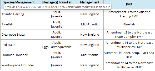
This notice initiates the Essential Fish Habitat consultation requirements of the Magnuson-Stevens Fishery Conservation and Management Act. Our initial determination is that the proposed action may adversely affect Essential Fish Habitat and/or fisheries managed by Fishery Management Councils and the NMFS. The effects of the project are determined to be minimal and permanent. These habitat(s) are utilized by the following species and their various life stages:
Our final determination relative to project impacts and the need for mitigation measures is subject to review by and coordination with the National Marine Fisheries Service.
NAVIGATION: The proposed structure or activity is not located in the vicinity of a federal navigation channel.
SECTION 408: The applicant will not require permission under Section 14 of the Rivers and Harbors Act of 1899 (33 USC 408) because the activity, in whole or in part, would not alter, occupy, or use a Corps Civil Works project.
WATER QUALITY CERTIFICATION: Water Quality Certification may be required from the Maryland Department of the Environment in accordance with Section 401 of the Clean Water Act.
NOTE: This public notice is being issued based on information furnished by the applicant. This information has not been verified or evaluated to ensure compliance with laws and regulation governing the regulatory program. The geographic extent of aquatic resources within the proposed project area that either are, or are presumed to be, within the Corps jurisdiction has not been verified by Corps personnel.
EVALUATION: The decision whether to issue a permit will be based on an evaluation of the probable impact including cumulative impacts of the proposed activity on the public interest. That decision will reflect the national concern for both protection and utilization of important resources. The benefits, which reasonably may be expected to accrue from the proposal, must be balanced against its reasonably foreseeable detriments. All factors which may be relevant to the proposal will be considered including cumulative impacts thereof; among these are conservation, economics, esthetics, general environmental concerns, wetlands, historical properties, fish and wildlife values, flood hazards, floodplain values, land use, navigation, shoreline erosion and accretion, recreation, water supply and conservation, water quality, energy needs, safety, food, and fiber production, mineral needs, considerations of property ownership, and in general, the needs and welfare of the people. Evaluation of the impact of the activity on the public interest will also include application of the guidelines promulgated by the Administrator, EPA, under authority of Section 404(b) of the Clean Water Act or the criteria established under authority of Section 102(a) of the Marine Protection Research and Sanctuaries Act of 1972. A permit will be granted unless its issuance is found to be contrary to the public interest.
COMMENTS: The Corps is soliciting comments from the public; Federal, State, and local agencies and officials; Indian Tribes; and other Interested parties in order to consider and evaluate the impacts of this proposed activity. Any comments received will be considered by the Corps to determine whether to issue, modify, condition, or deny a permit for this proposal. To make this determination, comments are used to assess impacts to endangered species, historic properties, water quality, general environmental effects, and the other public interest factors listed above. Comments are used in the preparation of an Environmental Assessment and/or an Environmental Impact Statement pursuant to the National Environmental Policy Act. Comments are also used to determine the need for a public hearing and to determine the overall public interest of the proposed activity.
The Baltimore District will receive written comments on the proposed work, as outlined above, until November 13, 2025. Comments should be submitted electronically via the Regulatory Request System (RRS) at https://rrs.usace.army.mil/rrs or to Erica Schmidt at erica.schmidt@usace.army.mil. Alternatively, you may submit comments in writing to the Commander, U.S. Army Corps of Engineers, Baltimore District, Attention: Erica Schmidt, 2 Hopkins Plaza CENAB-OPR Baltimore, MD 21201. Please refer to the permit application number in your comments.
Any person may request, in writing, within the comment period specified in this notice, that a public hearing be held to consider the application. Requests for public hearings shall state, with particularity, the reasons for holding a public hearing. Requests for a public hearing will be granted, unless the District Engineer determines that the issues raised are insubstantial or there is otherwise no valid interest to be served by a hearing.