Wicomico River Maintenance Dredging Project Update
 

Maintenance dredging for the Lower Wicomico River began in October 2023 and is expected to continue through December 2023. As of October 23, approximately 23,000 cubic yards of material has been removed from the first shoal and placed in Area 1 at Deal Island Wildlife Management Area placement site. 

Repairs to the straw bale containment wall at Deal Island caused by Tropical Storm Ophelia late September 2023 are also underway. This repair work began immediately following the storm to mitigate any impact the Wicomico project schedule. 

Once placement of dredge material is completed this winter, vegetation planting will take place over a two-year period. The material, comprising of mostly silt and sand, will be beneficially placed for wetland restoration meant to increase migratory bird nesting habitat.


Federal and State Partner Links

Wicomico County is the non-federal sponsor of the project, and Maryland DNR owns the Deal Island WMA placement site.

Past Public Meetings

2021 Public Meeting: This meeting provided stakeholders and the public the opportunity to learn more about the placement site history, efforts to identify suitable new placement sites, and factors that led to the selection of the Deal Island Wildlife Management Area for this cycle.

Wicomico River Maintenance Dredging Background

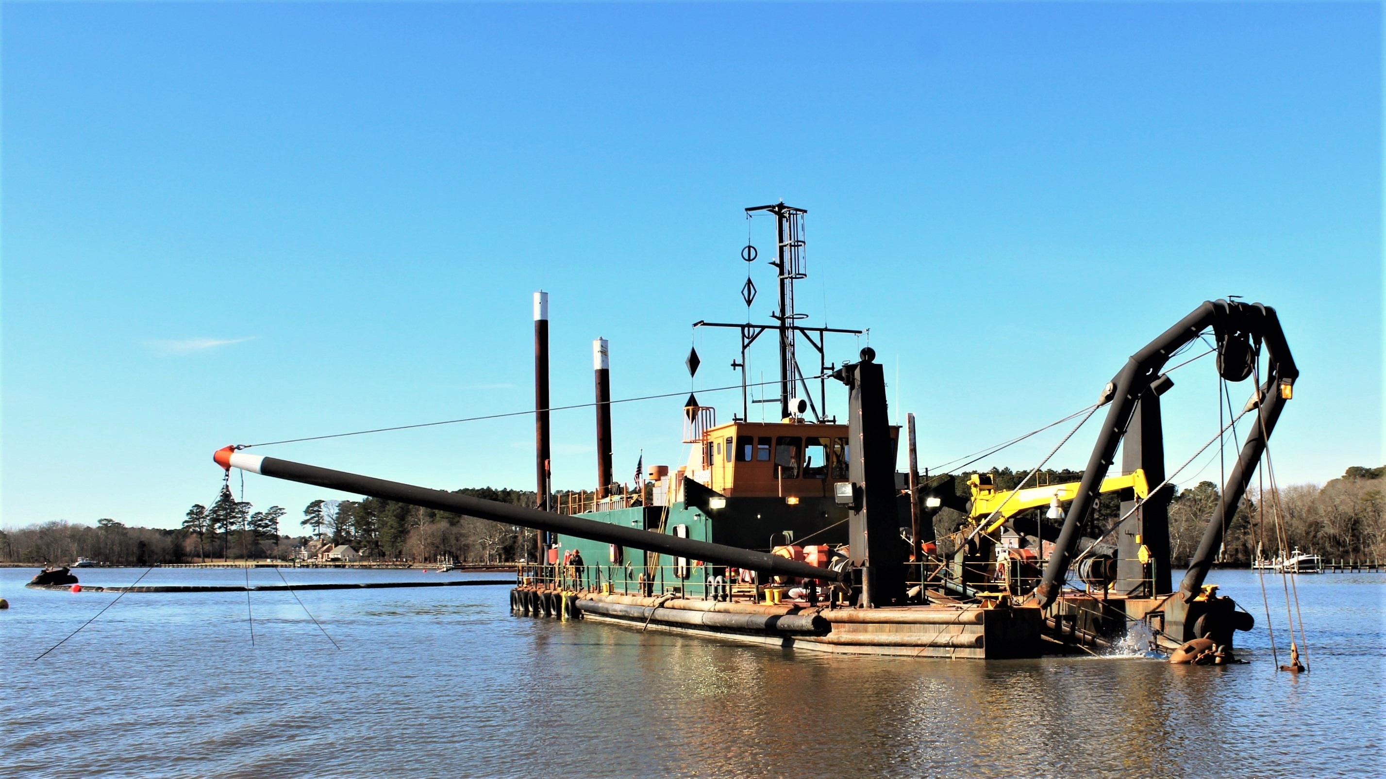
The U.S. Army Corps of Engineers, Baltimore District, provides maintenance dredging for the Federal navigation channel on the Wicomico River in Wicomico County, Maryland. The Wicomico River project was authorized by the River and Harbor Act of September 19, 1890, and modified in 1910, 1919, 1930,1937 and 1954.

This project contributes to protecting environmental habitat, improving water quality and expanding public access within the Chesapeake Bay watershed. The operations and maintenance project provides for a channel of 14 feet deep and 150 feet wide from the Chesapeake Bay to Salisbury, including 100-foot-wide channels with turning basins that are all 14 feet deep in the north and south prongs, and a 60-foot-wide channel 6 feet deep from deep water in the river to Webster Cove; a T-shaped basin in a cove that is 100 feet wide and 400 feet long, and an extension of a basin that is 200 feet long and 100 feet wide on each side. 

The total project length is 37 miles. The port of Salisbury has the second highest commercial port in Maryland, consisting primarily of petroleum products and grain. Safe barge passage is crucial to maintaining adequate fuel supplies for the Delmarva Peninsula.


Questions & Answers

Collapse All Expand All
 How is the dredge material moved to its final location?

The material will be dredged via a cutter suction dredge and hydraulically pumped through a pipeline from the dredge to the placement site. There will be no staging location or barges to move the material. The discharge end of the pipeline may be moved within the placement site to spread the dredged material.

 How/why was the Deal Island WMA site selected for dredged material placement?

USACE pumped the last dredging material to Clara Road in 2013. That site is now closed. A new suitable placement site for the dredged material from the Wicomico River needed to be found to ensure continued dredging and safe vessel passage.

Since 2008, USACE and its partners have been looking for new placement sites. Other considered placement sites had wetland mitigation issues, owners who did not want to sell their property, or land that would not have the space available for the appropriate dredged material. After long research and testing, USACE and its partners picked Deal Island WMA. This placement site can take sediment from the Wicomico River, while also rebuilding degraded tidal marshes that provide habitat for local species, including two threatened bird species, and filter sediment.

 In the 2017 dredging projects, the containment failed and the material polluted Ellis Bay. Will that be happening again?

There are significant differences between the characteristics of the Deal Island WMA and Ellis Bay placement sites. Ellis Bay was a shoreline restoration project, in which material was placed adjacent to the shoreline in open water. Whereas, placement at Deal Island will aim to restore eroding wetlands to provide habitat and improve resiliency. The multi-agency project team incorporated different design parameters and contributed to the overall site design, to include target elevation and containment features. A USACE representative will monitor the dredged material inflow and work closely with the contractor to ensure the target elevation of 1.5 feet above the existing grade is met. The placement site area is sufficient for the estimated amount of material to be placed, but operations will be shut down if any containment failures are identified.


 Is the dredged material toxic?

The sediment was sampled and tested in 2010 and fell within acceptable ranges. Necessary water quality certifications were issued for the Wicomico River project from the Maryland Department of the Environment on previous maintenance dredging cycles. In February 2021, sediment samples were collected at the previously used upland placement site for the lower portion of the Wicomico River. These sediment samples also showed contamination levels within acceptable ranges and suitable to plant and grow similar species of vegetation to be planted at the Deal Island WMA.

 What is the diameter of the pipe/hose you’re using? Are there any impacts to animals?

The diameter of the pipeline will depend on the winning contractor and the dredge and equipment they decide to use to meet the requirements of this work. Historically, this project has been dredged with equipment having a diameter between 16 - 24 inches. In coordination with our partner agencies, several environmental windows and time-of-year restrictions are set to avoid as much impact as possible to fish, other species and aquatic vegetation during both dredging and material placement. From February to June, we have listed the anadromous fish window. We will also avoid dredging during fish spawning timeframes in the Wicomico River.

 What is the general project schedule?

The U.S. Army Corps of Engineers (USACE), Baltimore District, awarded a $13.5 million contract to Cottrell Contracting Corp., a Small Business out of Chesapeake, Virginia, in September 2022 for maintenance dredging for the Lower Wicomico River, located in both Wicomico and Somerset counties. 

  • Maintenance dredging for the Lower Wicomico River began in October 2023 and is expected to continue through December 2023. Once placement of dredge material is completed winter 2023/2024, vegetation planting will take place over a two-year period.
  • The project – in coordination with Wicomico County, the non-federal sponsor – consists of dredging approximately 120,000 cubic yards of material from the federal navigation channel, to its authorized depth of 14 feet.   
 What is the price for this project?

USACE, Baltimore District awarded has awarded a $13.5 million contract to Cottrell Contracting Corp., a Small Business out of Chesapeake, Virginia, for maintenance dredging for the Lower Wicomico River. This includes the containment, dredging, and planting portions of the project.

 What is the timeline for this project?

Maintenance dredging for the Lower Wicomico River began in October 2023 and is expected to continue through December 2023. Once placement of dredge material is completed winter 2023/2024, vegetation planting will take place over a two-year period.

Following placement, vegetation will be planted over two growing seasons and monitoring will occur for up to five years.

 Where will the work will be starting?

The work is planned to commence at the southern end of the Wicomico River. Three main sections will have visible buoys for the dredging location in the Wicomico River. Please see the below buoy locations for the general areas of dredging:

  • Dredging Section 1
    • Start dredging after Green 9
    • End dredging at Green 15
  • Dredging Section 2
    • Start dredging before Green 17
    • End dredging at Green 19
  • Dredging Section 3
    • Start dredging before Green 23
    • End dredging before Red 22
 Will any flocculant be used?

No. 

 Will the newly placed material be in direct contact with wave action from the river?

Under normal wave conditions and habitat conditions, there should be no direct wave contact.

 Will the pipe be under water or on the surface during this dredging cycle? Will this impact oyster bars or vessels?

For the portion of work occurring on the river, the pipeline may be either submerged or floating but will be properly marked by the contractor in accordance with USACE and USCG regulations. A natural oyster bar is located near the southern end of the channel. Dredging for this section of the channel will be accomplished within the timeframe recommend by Maryland Department of Natural Resources in order to minimize potential impacts to the natural oyster bar. Additionally, USACE and its contractor will work with aquaculture leaseholders regarding the pipeline route to minimize impacts to leases near the federal channel to the maximum extent practicable.

Contract award

USACE recently awarded contract to dredge lower Wicomico River (as of Sept. 28, 2022) 

The U.S. Army Corps of Engineers (USACE), Baltimore District, has awarded a $13.5 million contract to Cottrell Contracting Corp., a Small Business out of Chesapeake, Virginia, for maintenance dredging for the Lower Wicomico River, located in both Wicomico and Somerset counties. 

  • The project – in coordination with Wicomico County, the non-federal sponsor – consists of dredging approximately 120,000 cubic yards of material from the federal navigation channel, to its authorized depth of 14 feet.   
  • Beneficial use material will be placed at Deal Island Wildlife Management Area (see project status). Deal Island supports one of the largest concentrations in the state of herons, egrets and ibis, and also hosts one of Maryland's only breeding population of black-necked stilts.   

View the Site Map (click)

Contact us!

If you have any questions, comments or concerns, please e-mail NAB-PAO@usace.army.mil for further information.