Montgomery County, MD Continuing Authorities Program 206 Study

In February 2010, the United States Army Corps of Engineers (USACE) in partnership with the Metropolitan Washington Council of Governments (MWCOG), along with other local jurisdictions and state and local resource agencies, completed the Anacostia Restoration Plan (ARP).  The ARP identified over 3,000 candidate projects for the restoration of the Anacostia River watershed. 

Following up on the 2010 plan, Montgomery County expressed interest in pursuing USACE implementation for restoration opportunities within their jurisdiction. The feasibility cost-sharing agreement (FCSA) was signed on October 8, 2013, under the General Investigation (GI) program. During the scoping phase of the General Investigations study, seven stream reaches in four sub watersheds of the Anacostia River watershed were identified as degraded and as candidates for further screening. The alternatives milestone meeting was completed on February 28, 2014. At the April 2015 pre-Tentatively Selected Plan (TSP) meeting, the Lamberton Tributary, Bel Pre Tributary, and Sligo Creek were identified as the TSP for stream restoration tributaries. Additionally at the TSP meeting, it was proposed to convert the project to the Continuing Authorities Program (CAP) given the size and cost of the TSP.

The transition to CAP was approved by the North Atlantic Division Commander on December 9, 2016. Montgomery County sent a letter of intent on November 14, 2017, to convert the GI study to the CAP feasibility phase. The Continuing Authorities Program (CAP) Section 206 FCSA was executed with Montgomery County on September 30, 2020. The CAP, Section 206 of the Aquatic Ecosystem Restoration, Water Resources Development Act of 1996, as amended, study will utilize the work and decisions made during the GI study, if reconfirmed. A basic assumption is that the TSP identified in 2015 is the starting point for the CAP study.

Project Setting and Sites

Montgomery County

The drainage of the Anacostia River within Montgomery County is approximately 61 square miles, accounting for about one-third of the total Anacostia River watershed.  The Anacostia River flows through Maryland and then the District of Columbia into the Potomac River; the river ultimately drains to the Chesapeake Bay.  Anacostia River sub-watersheds largely within Montgomery County include Sligo Creek, Northwest Branch, Paint Branch, and Little Paint Branch. The watershed in Montgomery County falls primarily within the Piedmont physiographic province.  However, along the county’s border with Prince George’s County, small sections of the streams lie within the Coastal Plain province. The Piedmont province is characterized by gently rolling to hilly topography separated by drained fertile valleys and narrow stream valleys, with elevations ranging from 200 to 570 feet above mean sea level. Streams are generally low to moderate gradient and are composed of coarser bed material, such as gravel or cobble. The very lower end of the watershed is in the Coastal Plain province, which is somewhat flatter and has lower gradient streams with finer bed materials.

Project Study Area

The TSP streams (Lamberton Tributary, Bel Pre Tributary, and Sligo Creek) largely flow through forested parkland but are incised and have degraded instream habitat. The streams have reduced stream/floodplain connection from conditions several decades ago, causing loss of ecosystem function and floodplain wetlands habitats. Water quality and habitat in the Anacostia River watershed are degraded as a result of anthropogenic alterations to the natural landscape. Additionally, fish blockages in the watershed prevent movement of resident and catadromous fish. 
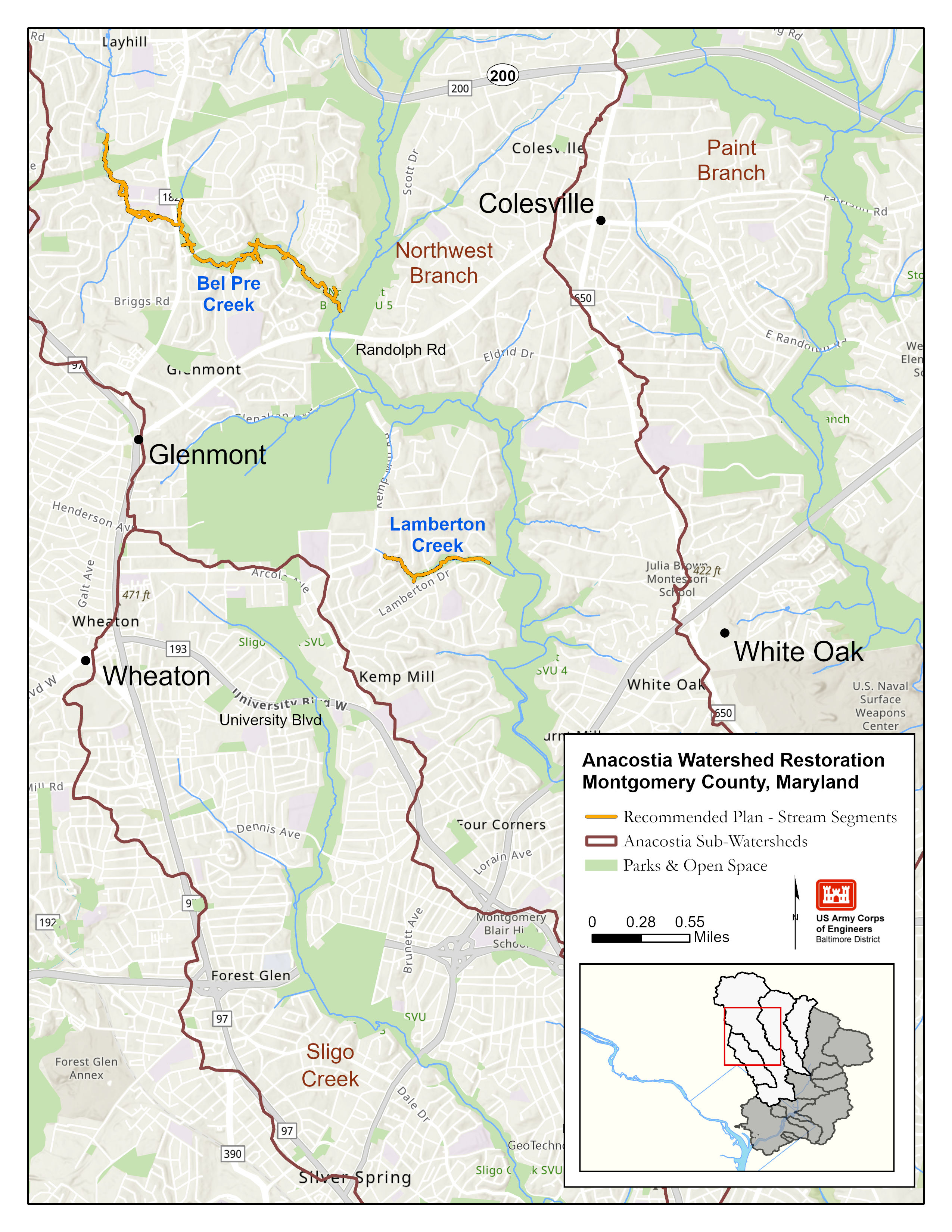
The goals of the project are to restore aquatic ecosystems in the selected stream reaches, enhance migratory fish movement upstream, and to connect functional habitat for fish.  The project seeks to contribute to a comprehensive restoration strategy by addressing in-stream habitat restoration while other agencies focus on water-quality improvements.

Bel Pre

The Bel Pre tributary stream segment is roughly 3.1 miles long. The Bel Pre tributary mainly has problems with erosion, trees uprooting, sediment loading, and lack of flood plain connectivity. The project at the Bel Pre tributary would realign parts of the channel to better convey the flow and reduce erosion, improve fish passage, and increase flood plain connectivity (including wetland areas).

Lamberton

The Lamberton tributary stream segment is roughly 1 mile long. The Lamberton tributary mainly has problems with lateral erosion and tree uprooting. The project at the Lamberton tributary would correct lateral movement and erosion and improve fish passage.

Sligo

The Sligo Creek/Colt Terrace Tributary stream segments roughly total 0.7 miles. Sligo Creek/Colt Terrace tributaries overall have problems with lack of floodplain connectivity. The project in Sligo Creek would reconnect the flood plain, and improve stability and aquatic habitat (including wetlands),

Sponsor/Cost Share

Montgomery County, Maryland is the non-federal sponsor for this project. Montgomery County and USACE will evenly split the $675,200 study costs. Additionally, as the primary landowner and due to their extensive experience in stream restoration, Maryland-National Capital Park and Planning Commission (M-NCPPC) will be an active participant in the coordination between USACE and Montgomery County Department of Environmental Protection (MCDEP).

CAP 206

Montgomery County